| ID Site | Photo | Description | Commune (Département) | Ville proche |
|
![Allée couverte - Etat normal - Position prise au GPS](/Megalithes/Ressources_WEB/icon24_DL3P.gif) | ALAUXE*3 | ![](/Megalithes/Photo/France/Preview/2011-08-18/DSC00765.JPG) | Allée couverte dite la Pierre aux Esprits Follets Kerjagu | Colpo (Morbihan) | Vannes |
![Allée couverte - Etat abîmé - Position prise au GPS](/Megalithes/Ressources_WEB/icon24_DL2P.gif) | ALBEAU*2 | ![](/Megalithes/Photo/France/Preview/Claude/56 Saint-Laurent-sur-Oust [3] allée couverte près de Beaumont (1).jpg) | Allée couverte de Beaumont Courtil aux Fées | Saint Laurent sur Oust (Morbihan) | Redon |
![Allée couverte - Etat abîmé - Position prise sur carte 1:25.000](/Megalithes/Ressources_WEB/icon24_DL2M.gif) | ALBEL0-2 | ![](/Megalithes/Photo/France/Preview/megalith-hunter/56 Saint Guyomard Allée couverte des Bellans Mich(1).JPG) | Allée couverte des Bellans Lande de Sournan | Saint Guyomard (Morbihan) | Vannes |
![Allée couverte - Etat remarquable - Position prise au GPS](/Megalithes/Ressources_WEB/icon24_DL4P.gif) | ALBIG0*4 | ![](/Megalithes/Photo/France/Preview/2007-07-19/100_7702.jpg) | Allée couverte de Roh Koh Koed Kerherne-Bodunan ; Bignon ; Roch-Koh-Coët | Saint Jean Brévelay (Morbihan) | Vannes |
![Allée couverte - Etat normal - Position prise au GPS](/Megalithes/Ressources_WEB/icon24_DL3P.gif) | ALBIG1*3 | ![](/Megalithes/Photo/France/Preview/2007-07-11/100_7453.jpg) | Allée couverte du Bignon
| Saint Guyomard (Morbihan) | Vannes |
![Allée couverte - Etat abîmé - Position prise au GPS](/Megalithes/Ressources_WEB/icon24_DL2P.gif) | ALBORD*2 | ![](/Megalithes/Photo/France/Preview/2008-08-28/100_9362.jpg) | Allée couverte de Bordouès Grée-Basse | Monteneuf (Morbihan) | Redon |
![Allée couverte - Etat exceptionnel - Position prise au GPS](/Megalithes/Ressources_WEB/icon24_DL5P.gif) | ALBOTE*5 | ![](/Megalithes/Photo/France/Preview/2007-07-26/100_7962.jpg) | Allée couverte de Bot-er-Mohed Bod-er-Mohet ; Campren-en-Torrigent | Cléguérec (Morbihan) | Pontivy |
![Allée couverte - Etat abîmé - Position prise sur carte 1:25.000](/Megalithes/Ressources_WEB/icon24_DL2M.gif) | ALBOTQ-2 | ![](/Megalithes/Photo/France/Preview/Claude/56 Priziac allée couverte près de Botquenven (1).jpg) | Allée couverte de Botquenven
| Priziac (Morbihan) | Lorient |
![Allée couverte - Etat ruiné - Position approximative](/Megalithes/Ressources_WEB/icon24_DL1.gif) | ALBRAM 1 | | Allée couverte de Brambelay
| Campénéac (Morbihan) | Redon |
![Allée couverte - Etat ruiné - Position approximative](/Megalithes/Ressources_WEB/icon24_DL1.gif) | ALCARH 1 | | Allée couverte du Carhon
| Saint Congard (Morbihan) | Redon |
![Allée couverte - Etat détruit - Position approximative](/Megalithes/Ressources_WEB/icon24_DLX.gif) | ALCONV X | | Allée couverte de Conveau
| Gourin (Morbihan) | Châteaulin |
![Allée couverte - Etat abîmé - Position prise sur carte 1:25.000](/Megalithes/Ressources_WEB/icon24_DL2M.gif) | ALCOUV-2 | ![](/Megalithes/Photo/France/Preview/Claude/56 Gourin allée couverte près de Men Guillonnet -.jpg) | Allée couverte dite Minguionnet Men-Guionnet ; Vil Huen ; Moulin blanc | Gourin (Morbihan) | Châteaulin |
![Allée couverte - Etat normal - Position prise au GPS](/Megalithes/Ressources_WEB/icon24_DL3P.gif) | ALFERM*3 | ![](/Megalithes/Photo/France/Preview/2021/IMG_20210124_154559.jpg) | Allée couverte de la ferme de Pont-Berto
| Plaudren (Morbihan) | Vannes |
![Allée couverte - Etat abîmé - Position approximative](/Megalithes/Ressources_WEB/icon24_DL2.gif) | ALFORT 2 | | Allée couverte de la Forêt de Molac (A)
| Cours (Morbihan) | Vannes |
![Allée couverte - Etat abîmé - Position prise sur carte 1:25.000](/Megalithes/Ressources_WEB/icon24_DL2M.gif) | ALGAJA-2 | ![](/Megalithes/Photo/France/Preview/megalith-hunter/100_0955.JPG) | Allée couverte de La Gajal
| Caro (Morbihan) | Redon |
![Allée couverte - Etat normal - Position prise au GPS](/Megalithes/Ressources_WEB/icon24_DL3P.gif) | ALGRA1*3 | ![](/Megalithes/Photo/France/Preview/2011-12-26/DSC01782.JPG) | Allée couverte du Grand-Village
| Caro (Morbihan) | Redon |
![Allée couverte - Etat détruit - Position approximative](/Megalithes/Ressources_WEB/icon24_DLX.gif) | ALGRA2 X | | Allée couverte du Grand-Village Ouest
| Caro (Morbihan) | Redon |
![Allée couverte - Etat ruiné - Position prise au GPS](/Megalithes/Ressources_WEB/icon24_DL1P.gif) | ALGRET*1 | ![](/Megalithes/Photo/France/Preview/Jérèmy/Allée couverte de la grée Trevelot St Servant.JPG) | Allée couverte de la Grée de Trévelot
| Saint Servant (Morbihan) | Vannes |
![Allée couverte - Etat remarquable - Position prise au GPS](/Megalithes/Ressources_WEB/icon24_DL4P.gif) | ALHINO*4 | | Allée couverte du Hino
| Ploërmel (Morbihan) | Redon |
![Allée couverte - Etat abîmé - Position prise au GPS](/Megalithes/Ressources_WEB/icon24_DL2P.gif) | ALKER0*2 | ![](/Megalithes/Photo/France/Preview/2019/DSC05859.JPG) | Allée couverte de Kerlano
| Plumelec (Morbihan) | Vannes |
![Allée couverte - Etat remarquable - Position prise au GPS](/Megalithes/Ressources_WEB/icon24_DL4P.gif) | ALKER1*4 | ![](/Megalithes/Photo/France/Preview/2011-08-24/DSC01309.JPG) | Allée couverte de Kerviniou
| Guiscriff (Morbihan) | Lorient |
![Allée couverte - Etat remarquable - Position prise au GPS](/Megalithes/Ressources_WEB/icon24_DL4P.gif) | ALKER7*4 | ![](/Megalithes/Photo/France/Preview/megalith-hunter/kergonfaltz alker7.jpg) | Allée couverte de Kergonfalz
| Bignan (Morbihan) | Vannes |
![Allée couverte - Etat abîmé - Position prise sur carte 1:25.000](/Megalithes/Ressources_WEB/icon24_DL2M.gif) | ALKER9-2 | ![](/Megalithes/Photo/France/Preview/Claude/56 Lanvénégen allée couverte --.jpg) | Allée couverte de Keroual
| Lanvénégen (Morbihan) | Lorient |
![Allée couverte - Etat détruit - Position approximative](/Megalithes/Ressources_WEB/icon24_DLX.gif) | ALKERE X | | Allée couverte de Kergus
| Gourin (Morbihan) | Châteaulin |
![Allée couverte - Etat détruit - Position prise sur carte 1:25.000](/Megalithes/Ressources_WEB/icon24_DLX.gif) | ALKERJ X | | Allée couverte de Kersimon
| Plumelec (Morbihan) | Vannes |
![Allée couverte - Etat détruit - Position approximative](/Megalithes/Ressources_WEB/icon24_DLX.gif) | ALKERS X | | Allée couverte de Kerscoul
| Languidic (Morbihan) | Pontivy |
![Allée couverte - Etat ruiné - Position prise sur carte 1:25.000](/Megalithes/Ressources_WEB/icon24_DL1M.gif) | ALLAN1-1 | | Allée couverte du Lannic
| Ploërdut (Morbihan) | Pontivy |
![Allée couverte - Etat abîmé - Position prise au GPS](/Megalithes/Ressources_WEB/icon24_DL2P.gif) | ALLANN*2 | ![](/Megalithes/Photo/France/Preview/Claude/56 Camors allée couverte près de Lann er Vein.jpg) | Allée couverte de Lann-er-Veinn
| Camors (Morbihan) | Pontivy |
![Allée couverte - Etat abîmé - Position prise au GPS](/Megalithes/Ressources_WEB/icon24_DL2P.gif) | ALLETO*2 | ![](/Megalithes/Photo/France/Preview/2011-08-16/DSC00639.JPG) | Allée couverte de l'Etoile Crenan | Camors (Morbihan) | Pontivy |
![Allée couverte - Etat exceptionnel - Position approximative](/Megalithes/Ressources_WEB/icon24_DL5.gif) | ALLOBO 5 | ![](/Megalithes/Photo/France/Preview/megalith-hunter/Photo0457.jpg) | 
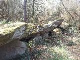
Allée couverte de Lobo Haut-Pinel | Caro (Morbihan) | Redon |
![Allée couverte - Etat abîmé - Position prise sur carte 1:25.000](/Megalithes/Ressources_WEB/icon24_DL2M.gif) | ALLOGE-2 | ![](/Megalithes/Photo/France/Preview/megalith-hunter/loge morinais - alloge.jpg) | Allée couverte de La Loge Morinais Côte ; La Voltais | Monteneuf (Morbihan) | Redon |
![Allée couverte - Etat abîmé - Position approximative](/Megalithes/Ressources_WEB/icon24_DL2.gif) | ALMANN 2 | | Allée couverte de Mane Nestrean
| Languidic (Morbihan) | Lorient |
![Allée couverte - Etat ruiné - Position prise sur carte 1:25.000](/Megalithes/Ressources_WEB/icon24_DL1M.gif) | ALMENB-1 | ![](/Megalithes/Photo/France/Preview/Claude/56 Camors sépulture mégalithique au sud du carrefour de l Etoile.jpg) | Allée couverte de Men Braz Men-Vras | Camors (Morbihan) | Pontivy |
![Allée couverte - Etat normal - Position prise au GPS](/Megalithes/Ressources_WEB/icon24_DL3P.gif) | ALMENG*3 | ![](/Megalithes/Photo/France/Preview/2011-08-18/DSC00793.JPG) | Allée couverte de Men-Gouarec'h Men-Gouarec | Plaudren (Morbihan) | Vannes |
![Allée couverte - Etat abîmé - Position prise sur carte 1:25.000](/Megalithes/Ressources_WEB/icon24_DL2M.gif) | ALMONT-2 | ![](/Megalithes/Photo/France/Preview/Claude/56 Saint-Congard allée couverte près de la Secouette (1).jpg) | Allée couverte du Mont-Hersé
| Saint Congard (Morbihan) | Redon |
![Allée couverte - Etat abîmé - Position prise sur carte 1:25.000](/Megalithes/Ressources_WEB/icon24_DL2M.gif) | ALNIZO-2 | ![](/Megalithes/Photo/France/Preview/Claude/56 Malguénac, allée couverte au sud de Saint-Nicolas (1).jpg) | Allée couverte de Saint-Nizon
| Malguénac (Morbihan) | Pontivy |
![Allée couverte - Etat détruit - Position approximative](/Megalithes/Ressources_WEB/icon24_DLX.gif) | ALPARK X | | Allée couverte de Park-er-Bé
| Cléguérec (Morbihan) | Pontivy |
![Allée couverte - Etat normal - Position prise au GPS](/Megalithes/Ressources_WEB/icon24_DL3P.gif) | ALPASG+3 | ![](/Megalithes/Photo/France/Preview/megalith-hunter/100_0961.JPG) | 
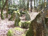
Allée couverte dite la Maison du Diable Lande de La Chapelle | Chapelle Caro (Morbihan) | Redon |
![Allée couverte - Etat normal - Position prise au GPS](/Megalithes/Ressources_WEB/icon24_DL3P.gif) | ALPIEC*3 | ![](/Megalithes/Photo/France/Preview/2008-08-28/100_9366.jpg) | Allée couverte dite La Pièce couverte Clos-Boschet ; Clos Boscher | Monteneuf (Morbihan) | Redon |
![Allée couverte - Etat détruit - Position approximative](/Megalithes/Ressources_WEB/icon24_DLX.gif) | ALPRAY X | | Allée couverte du Pray
| Caro (Morbihan) | Redon |
![Allée couverte - Etat ruiné - Position approximative](/Megalithes/Ressources_WEB/icon24_DL1.gif) | ALROC0 1 | ![](/Megalithes/Photo/France/Preview/megalith-hunter/bretagne fevrier 2008 025.jpg) | Allée couverte dite Le Rocher
| Concoret (Morbihan) | Rennes |
![Allée couverte - Etat abîmé - Position approximative](/Megalithes/Ressources_WEB/icon24_DL2.gif) | ALROCH 2 | ![](/Megalithes/Photo/France/Preview/Claude/56 Augan allée couverte près de la Coudraie.jpg) | Allée couverte dite la Roche des Fées La Coudraie | Augan (Morbihan) | Redon |
![Allée couverte - Etat normal - Position prise au GPS](/Megalithes/Ressources_WEB/icon24_DL3P.gif) | ALROHE*3 | ![](/Megalithes/Photo/France/Preview/2011-12-26/DSC01781.JPG) | Allée couverte de Roherman Roermand ; Niche à Gobineau ; Hutte à Gobineau | Augan (Morbihan) | Redon |
![Allée couverte - Etat détruit - Position prise sur carte 1:25.000](/Megalithes/Ressources_WEB/icon24_DLX.gif) | ALROHL X | | Allée couverte de Rohlas
| Languidic (Morbihan) | Pontivy |
![Allée couverte - Etat normal - Position prise au GPS](/Megalithes/Ressources_WEB/icon24_DL3P.gif) | ALROHP*3 | ![](/Megalithes/Photo/France/Preview/2007-07-24/100_7879.jpg) | Allée couverte de Roc'h-Prioldi Prieuré ; Roh-Prioldi ; Roch-Pri | Baud (Morbihan) | Pontivy |
![Allée couverte - Etat abîmé - Position prise sur carte 1:25.000](/Megalithes/Ressources_WEB/icon24_DL2M.gif) | ALSIGR-2 | | Allée couverte du Sigré
| Carentoir (Morbihan) | Redon |
![Allée couverte - Etat abîmé - Position prise au GPS](/Megalithes/Ressources_WEB/icon24_DL2P.gif) | ALTRBI+2 | ![](/Megalithes/Photo/France/Preview/Claude/56 Bohal allée couverte près de Trébiguet (3).jpg) | Allée couverte de Trébiguet Landier du Pont | Bohal (Morbihan) | Vannes |
![Allée couverte - Etat abîmé - Position prise au GPS](/Megalithes/Ressources_WEB/icon24_DL2P.gif) | ALTRLA*2 | ![](/Megalithes/Photo/France/Preview/2008-08-23/100_9148.jpg) | Allée couverte de Trélan
| Saint Marcel (Morbihan) | Vannes |
![Allée couverte - Etat ruiné - Position prise sur carte 1:25.000](/Megalithes/Ressources_WEB/icon24_DL1M.gif) | ALVIL2-1 | ![](/Megalithes/Photo/France/Preview/Claude/56 Guer allée couverte au lieu-dit le Rocher Maheux.jpg) | Allée couverte de la Ville-Boscher La Lande | Guer (Morbihan) | Redon |
![Allée couverte - Etat normal - Position prise au GPS](/Megalithes/Ressources_WEB/icon24_DL3P.gif) | ALVIL3*3 | ![](/Megalithes/Photo/France/Preview/2011-08-27/DSC01592.JPG) | Allée couverte de Ville-Bouquet Maison du diable | Ploërmel (Morbihan) | Vannes |
![Chambre funéraire - Etat inconnu - Position prise sur carte 1:25.000](/Megalithes/Ressources_WEB/icon24_DL0M.gif) | CFROST-0 | | Dolmen de Rostren
| Priziac (Morbihan) | Pontivy |
![Dolmen - Etat ruiné - Position approximative](/Megalithes/Ressources_WEB/icon24_DL1.gif) | DLBCIH 1 | | Sépulture de Bécihan
| Monteneuf (Morbihan) | Redon |
![Dolmen - Etat ruiné - Position prise sur carte 1:25.000](/Megalithes/Ressources_WEB/icon24_DL1M.gif) | DLBHL0-1 | ![](/Megalithes/Photo/France/Preview/Claude/56 Bohal vestiges du dolmen VII près des Hardys-Béhélec.jpg) | Dolmen de Béhélec (G)
| Bohal (Morbihan) | Vannes |
![Dolmen - Etat abîmé - Position prise sur carte 1:25.000](/Megalithes/Ressources_WEB/icon24_DL2M.gif) | DLBHL1-2 | ![](/Megalithes/Photo/France/Preview/Claude/56 Bohal dolmen VIII près des Hardys-Béhélec (1).jpg) | Dolmen de Béhélec (H)
| Bohal (Morbihan) | Vannes |
![Dolmen - Etat inconnu - Position prise sur carte 1:25.000](/Megalithes/Ressources_WEB/icon24_DL0M.gif) | DLBHLE-0 | | Dolmens de Béhélec
| Saint Marcel (Morbihan) | Vannes |
![Dolmen - Etat abîmé - Position prise au GPS](/Megalithes/Ressources_WEB/icon24_DL2P.gif) | DLCADI*2 | ![](/Megalithes/Photo/France/Preview/2021/IMG_20210124_142508.jpg) | Dolmen de Cadio
| Plaudren (Morbihan) | Vannes |
![Dolmen - Etat ruiné - Position approximative](/Megalithes/Ressources_WEB/icon24_DL1.gif) | DLCOIN 1 | | Dolmen du Coin-de-l'Or
| Saint Abraham (Morbihan) | Redon |
![Dolmen - Etat normal - Position prise sur carte 1:25.000](/Megalithes/Ressources_WEB/icon24_DL3M.gif) | DLCOL2-3 | | Dolmen de la Colline de Kermarhic
| Languidic (Morbihan) | Lorient |
![Dolmen - Etat abîmé - Position prise au GPS](/Megalithes/Ressources_WEB/icon24_DL2P.gif) | DLCOTE*2 | ![](/Megalithes/Photo/France/Preview/Claude/56 Saint-Allouestre dolmen près de Gunestre -.jpg) | Dolmen de Coët-er-Rui Guenestre | Saint Allouestre (Morbihan) | Pontivy |
![Dolmen - Etat abîmé - Position approximative](/Megalithes/Ressources_WEB/icon24_DL2.gif) | DLCOUG 2 | | Dolmen de la Forêt de Molac (B)
| Cours (Morbihan) | Vannes |
![Dolmen - Etat ruiné - Position approximative](/Megalithes/Ressources_WEB/icon24_DL1.gif) | DLCOUH 1 | | Dolmen de la Forêt de Molac (C)
| Cours (Morbihan) | Vannes |
![Dolmen - Etat normal - Position prise sur carte 1:25.000](/Megalithes/Ressources_WEB/icon24_DL3M.gif) | DLDO05-3 | ![](/Megalithes/Photo/France/Preview/megalith-hunter/DSC00618.JPG) | Dolmen de la Grée
| Plaudren (Morbihan) | Vannes |
![Dolmen - Etat abîmé - Position prise sur carte 1:25.000](/Megalithes/Ressources_WEB/icon24_DL2M.gif) | DLDO41-2 | | Dolmens du Bünz
| Inzinzac Lochrist (Morbihan) | Lorient |
![Dolmen - Etat ruiné - Position approximative](/Megalithes/Ressources_WEB/icon24_DL1.gif) | DLDO49 1 | | Dolmen de Lémo
| Augan (Morbihan) | Redon |
![Dolmen - Etat détruit - Position approximative](/Megalithes/Ressources_WEB/icon24_DLX.gif) | DLDOLK X | | Dolmen de la Motte
| Colpo (Morbihan) | Vannes |
![Dolmen - Etat inconnu - Position prise sur carte 1:25.000](/Megalithes/Ressources_WEB/icon24_DL0M.gif) | DLENS1-0 | | Dolmens de Béhélec Hardys | Saint Marcel (Morbihan) | Vannes |
![Dolmen - Etat remarquable - Position prise au GPS](/Megalithes/Ressources_WEB/icon24_DL4P.gif) | DLFOL3*4 | ![](/Megalithes/Photo/France/Preview/2007-07-18/100_7632.jpg) | 
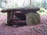
Dolmen dit des Follets
| Saint Gravé (Morbihan) | Redon |
![Dolmen - Etat abîmé - Position approximative](/Megalithes/Ressources_WEB/icon24_DL2.gif) | DLFOR2 2 | | Dolmen de la Forêt de Molac (A)
| Cours (Morbihan) | Vannes |
![Dolmen - Etat normal - Position prise sur carte 1:25.000](/Megalithes/Ressources_WEB/icon24_DL3M.gif) | DLGUI0-3 | ![](/Megalithes/Photo/France/Preview/Claude/56 Plouray, dolmen près de Guidfosse.jpg) | Dolmen de Guidfosse Guidefosse ; En er Huennou d'Endiass ; Parc er Crueno ; Parc er Eveno | Plouray (Morbihan) | Pontivy |
![Dolmen - Etat détruit - Position prise sur carte 1:25.000](/Megalithes/Ressources_WEB/icon24_DLX.gif) | DLHAYE X | | Dolmen de la Haye
| Saint Gravé (Morbihan) | Redon |
![Dolmen - Etat normal - Position prise au GPS](/Megalithes/Ressources_WEB/icon24_DL3P.gif) | DLKE10*3 | ![](/Megalithes/Photo/France/Preview/2007-08-02/100_8149.jpg) | Dolmen dit de Kermorvant Resto | Moustoir Ac (Morbihan) | Vannes |
![Dolmen - Etat inconnu - Position inconnue (centre de la commune donnée)](/Megalithes/Ressources_WEB/icon24_DL0X.gif) | DLKE90X0 | | Dolmen de Kerlatu Moho | Baud (Morbihan) | Pontivy |
![Dolmen - Etat remarquable - Position prise au GPS](/Megalithes/Ressources_WEB/icon24_DL4P.gif) | DLKEA0*4 | ![](/Megalithes/Photo/France/Preview/2007-07-21/100_7861.jpg) | Dolmen de Kergonfalz Trou des Chouans | Bignan (Morbihan) | Vannes |
![Dolmen - Etat détruit - Position approximative](/Megalithes/Ressources_WEB/icon24_DLX.gif) | DLKEK0 X | | Dolmen de Kergueris
| Calan (Morbihan) | Lorient |
![Dolmen - Etat normal - Position prise au GPS](/Megalithes/Ressources_WEB/icon24_DL3P.gif) | DLKER5*3 | ![](/Megalithes/Photo/France/Preview/Jacques_22/16-Dolmen de Kermabon-Bieuzy-56-ret.jpg) | Dolmen de Kermabon En-Tri-Mein; les Trois Pierres | Bieuzy (Morbihan) | Pontivy |
![Dolmen - Etat abîmé - Position prise sur carte 1:25.000](/Megalithes/Ressources_WEB/icon24_DL2M.gif) | DLKERF-2 | ![](/Megalithes/Photo/France/Preview/Claude/56 Elven dolmens dans le Bois de Kerfily dolmen au nord du talus.jpg) | Dolmens du Château de Kerfily
| Elven (Morbihan) | Vannes |
![Dolmen - Etat normal - Position prise au GPS](/Megalithes/Ressources_WEB/icon24_DL3P.gif) | DLKERU*3 | ![](/Megalithes/Photo/France/Preview/2021/IMG_20210124_144603.jpg) | Dolmen de Keruzan
| Saint Jean Brévelay (Morbihan) | Vannes |
![Dolmen - Etat inconnu - Position inconnue (centre de la commune donnée)](/Megalithes/Ressources_WEB/icon24_DL0X.gif) | DLKES0X0 | | Dolmen de Kermavon
| Pluvigner (Morbihan) | Vannes |
![Dolmen - Etat remarquable - Position prise au GPS](/Megalithes/Ressources_WEB/icon24_DL4P.gif) | DLLAR0*4 | ![](/Megalithes/Photo/France/Preview/2007-07-28/100_7990.jpg) | Cairn de Larcuste Min Groh Ru | Colpo (Morbihan) | Vannes |
![Dolmen - Etat remarquable - Position prise au GPS](/Megalithes/Ressources_WEB/icon24_DL4P.gif) | DLLARC*4 | ![](/Megalithes/Photo/France/Preview/2007-07-28/100_7994.jpg) | Cairn de Larcuste (B)
| Colpo (Morbihan) | Vannes |
![Dolmen - Etat abîmé - Position prise sur carte 1:25.000](/Megalithes/Ressources_WEB/icon24_DL2M.gif) | DLLOS0-2 | ![](/Megalithes/Photo/France/Preview/megalith-hunter/100_1048.JPG) | Cairn de Lost-er-Lenn
| Grand Champ (Morbihan) | Vannes |
![Dolmen - Etat abîmé - Position prise sur carte 1:25.000](/Megalithes/Ressources_WEB/icon24_DL2M.gif) | DLMADR-2 | ![](/Megalithes/Photo/France/Preview/Yannick/P1010749.jpg) | Dolmen de Madry
| Tréal (Morbihan) | Redon |
![Dolmen - Etat ruiné - Position prise sur carte 1:25.000](/Megalithes/Ressources_WEB/icon24_DL1M.gif) | DLMAI5-1 | ![](/Megalithes/Photo/France/Preview/Claude/56 le Cours dolmen près de l Ermitage.jpg) | Dolmen de la Maison de la Forêt Bâtiment-de-la-Fôret | Cours (Morbihan) | Vannes |
![Dolmen - Etat remarquable - Position prise au GPS](/Megalithes/Ressources_WEB/icon24_DL4P.gif) | DLMAI6*4 | ![](/Megalithes/Photo/France/Preview/2007-07-20/100_7767.jpg) | 
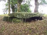
Dolmen dit Maison-Trouvée La Ville-au-Voyer ; Maison-Trouée | Chapelle Caro (Morbihan) | Redon |
![Dolmen - Etat détruit - Position prise au GPS](/Megalithes/Ressources_WEB/icon24_DLX.gif) | DLMENG X | | Dolmen de Men-Gouarec'h
| Plaudren (Morbihan) | Vannes |
![Dolmen - Etat ruiné - Position prise sur carte 1:25.000](/Megalithes/Ressources_WEB/icon24_DL1M.gif) | DLMIC0-1 | | Dolmen des Miches (B)
| Elven (Morbihan) | Vannes |
![Dolmen - Etat abîmé - Position prise sur carte 1:25.000](/Megalithes/Ressources_WEB/icon24_DL2M.gif) | DLMICH-2 | | Dolmen des Miches
| Elven (Morbihan) | Vannes |
![Dolmen - Etat abîmé - Position prise au GPS](/Megalithes/Ressources_WEB/icon24_DL2P.gif) | DLREST*2 | ![](/Megalithes/Photo/France/Preview/2021/IMG_20210228_145258.jpg) | Dolmen du Resto
| Moustoir Ac (Morbihan) | Vannes |
![Dolmen - Etat remarquable - Position prise au GPS](/Megalithes/Ressources_WEB/icon24_DL4P.gif) | DLROC8*4 | ![](/Megalithes/Photo/France/Preview/2008-08-28/100_9312.jpg) | Dolmens dits Roche de Migourdy
| Plumelec (Morbihan) | Vannes |
![Dolmen - Etat normal - Position prise au GPS](/Megalithes/Ressources_WEB/icon24_DL3P.gif) | DLROH1*3 | ![](/Megalithes/Photo/France/Preview/2007-08-02/100_8169.jpg) | Dolmen de Roh-Du Rode; Loge Golvan | Chapelle Neuve (Morbihan) | Vannes |
![Dolmen - Etat ruiné - Position prise sur carte 1:25.000](/Megalithes/Ressources_WEB/icon24_DL1M.gif) | DLROHB-1 | ![](/Megalithes/Photo/France/Preview/Claude/56 la Chapelle-Neuve dolmen à l ouest de Roh Du .jpg) | Dolmen de Roh Du (C)
| Chapelle Neuve (Morbihan) | Vannes |
![Dolmen - Etat abîmé - Position prise sur carte 1:25.000](/Megalithes/Ressources_WEB/icon24_DL2M.gif) | DLROHC-2 | ![](/Megalithes/Photo/France/Preview/Claude/56 la Chapelle-Neuve dolmen à l est de Roh Du.jpg) | Dolmen de Roh Du (B)
| Chapelle Neuve (Morbihan) | Vannes |
![Dolmen - Etat détruit - Position approximative](/Megalithes/Ressources_WEB/icon24_DLX.gif) | DLROUT X | | Dolmen de la route de Saint-Jean
| Plumelec (Morbihan) | Vannes |
![Dolmen - Etat détruit - Position approximative](/Megalithes/Ressources_WEB/icon24_DLX.gif) | DLSAUD X | | Dolmen de la Saudraie
| Mauron (Morbihan) | Rennes |
![Dolmen - Etat inconnu - Position prise sur carte 1:25.000](/Megalithes/Ressources_WEB/icon24_DL0M.gif) | DLSOUC-0 | | Dolmen de Soucho
| Pluvigner (Morbihan) | Vannes |
![Dolmen - Etat remarquable - Position prise au GPS](/Megalithes/Ressources_WEB/icon24_DL4P.gif) | DLTA03*4 | ![](/Megalithes/Photo/France/Preview/2007-07-13/100_7487.jpg) | Dolmen dit des Tablettes
| Cournon (Morbihan) | Redon |
![Dolmen - Etat ruiné - Position prise sur carte 1:25.000](/Megalithes/Ressources_WEB/icon24_DL1M.gif) | DLTOU7-1 | | Dolmen de Toul-er-Rest
| Camors (Morbihan) | Pontivy |
![Dolmen - Etat ruiné - Position approximative](/Megalithes/Ressources_WEB/icon24_DL1.gif) | DLTOU8 1 | | Dolmen de la Touche-Carnée
| Roc Saint André (Morbihan) | Vannes |
![Dolmen - Etat abîmé - Position prise sur carte 1:25.000](/Megalithes/Ressources_WEB/icon24_DL2M.gif) | DLTRBR-2 | ![](/Megalithes/Photo/France/Preview/megalithesdumorbihan/DCPLUMAD56_4.jpg) | Dolmen de Trébrun Maderans | Pluherlin (Morbihan) | Redon |
![Dolmen - Etat détruit - Position approximative](/Megalithes/Ressources_WEB/icon24_DLX.gif) | DLVERG X | | Dolmen du Verger
| Plouay (Morbihan) | Lorient |
|
| Page suivante |
|
Réponse | 1-100/207 |