 Accueil Accueil
Notice
Histoire
Rôle(s)
Catégories
Liens
GpsPasSion
Versions
Bibliographie
Gargantua
Les Fées
|

 France - Menhir de Landre (B) [MHLA04] France - Menhir de Landre (B) [MHLA04]
|
Les 30 sites les plus proches :
| Distance | | ID Site | Photo | Description | Commune
(Département) | Ville proche |
|---|
|
| 0 Km | | MHLA04+1 |  | Menhir de Landre (B)
| Blandas
(Gard) | Vigan |
| 0,2 Km |  | MHLA03+3 |  | Menhir de Landre
Pèira Plantada | Blandas
(Gard) | Vigan |
| 1 Km | | MHSOTC+1 | 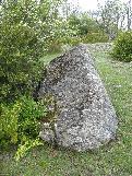 | Menhir du Sotch des Genièvres
| Blandas
(Gard) | Vigan |
| 1,1 Km |  | DLFOU2+2 | 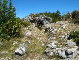 | Dolmen d'Arques
Landre | Blandas
(Gard) | Vigan |
| 1,5 Km |  | LHPLAN+5 | 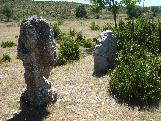 | Cromlech de Lacam de Peyrarines
Planas | Blandas
(Gard) | Vigan |
| 1,7 Km |  | MHBELF+4 | | Menhir des Combes
| Blandas
(Gard) | Vigan |
| 1,8 Km |  | DLPLA5+4 | 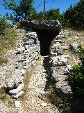 | Dolmen de Planas
| Blandas
(Gard) | Vigan |
| 1,8 Km |  | MHPLAM-1 | | Menhir de Planas (A)
| Blandas
(Gard) | Vigan |
| 1,8 Km |  | LHPLA0 1 | | Cromlech de Planas (B)
| Blandas
(Gard) | Vigan |
| 1,9 Km |  | MSBELF+3 | | Menhirs d'Avernat
Coste Plane | Blandas
(Gard) | Vigan |
| 2 Km | | MHLAV0+1 |  | Menhir de la Lavagne
| Blandas
(Gard) | Vigan |
| 2 Km | | MHPLA4+3 | 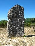 | Menhir de Planas
Serre de la Gleisa; Gleyze | Blandas
(Gard) | Vigan |
| 2,2 Km |  | LHLACA+4 | 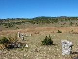 | Cromlech de Lacam de la Rigalderie
Mercoulines | Blandas
(Gard) | Vigan |
| 2,4 Km | | MHSER1+1 |  | Menhir de la Serre de la Tune
| Arre
(Gard) | Vigan |
| 2,4 Km |  | LHLAC0+1 | | Cromlech de Lacam de la Rigalderie (B)
| Blandas
(Gard) | Vigan |
| 2,5 Km | | DLPE08+4 |  | Dolmen dit Peyre Cabucelade
Pèira Cabucèlada; Serre de la Tune; Ostalet de las Fadas | Arre
(Gard) | Vigan |
| 2,6 Km | | DLREG0+2 | 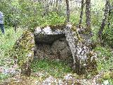 | Dolmen de Regos
| Blandas
(Gard) | Vigan |
| 3,1 Km |  | DLDASS+1 | .jpg) | Dolmen du Château d'Assas
| Blandas
(Gard) | Vigan |
| 3,8 Km | | MHTRA2+1 | 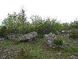 | Menhir du Travers des Noyers
| Blandas
(Gard) | Vigan |
| 3,9 Km |  | DLBAR4+3 | 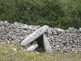 | Dolmen de Barral
| Blandas
(Gard) | Vigan |
| 4,1 Km | | DLDO31+1 |  | Dolmens d'Airoles (B)
| Alzon
(Gard) | Vigan |
| 4,1 Km | | DLDAIR+2 |  | Dolmen d'Airoles
Pierre au Diable; Pallet de Gargantua; Ayrolles | Alzon
(Gard) | Vigan |
| 4,5 Km | | MHCAUC+1 |  | Menhir de Caucalière
| Montdardier
(Gard) | Vigan |
| 4,5 Km | | DLCAUC+2 | 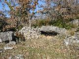 | Dolmen de la Caucalière
| Montdardier
(Gard) | Vigan |
| 4,5 Km |  | MHLAC0 1 | | Menhir de Lacam
| Rogues
(Gard) | Vigan |
| 4,6 Km | | DLDO30+2 | .jpg) | Dolmens d'Aurières (B)
| Alzon
(Gard) | Vigan |
| 4,6 Km |  | MHCOLE+2 | 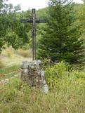 | Menhir du Col d'Aurières
| Alzon
(Gard) | Vigan |
| 4,8 Km | | DLDAUR+3 | 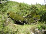 | Dolmen d'Aurières (A)
| Alzon
(Gard) | Vigan |
| 4,9 Km | | DLBOR2+3 | 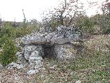 | Dolmen de la Borie d'Arre (A)
| Blandas
(Gard) | Vigan |
| 4,9 Km | | DLBOR7+2 | 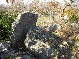 | Dolmen de la Borie d'Arre (B)
| Rogues
(Gard) | Vigan |
| 4,9 Km | | DLBOR8+2 |  | Dolmen de la Borie d'Arre (C)
| Rogues
(Gard) | Vigan |
|
|
| © 2004-2024 T4T35 - Version du 3 décembre 2020 22:31 - Email : T4T35 |
|

 Belgique
 Ecosse
 France
 Irlande
 Pays de Galles