 Accueil Accueil
Notice
Histoire
Rôle(s)
Catégories
Liens
GpsPasSion
Versions
Bibliographie
Gargantua
Les Fées
|

 France - Menhir de la Pierre-à-Midi [MHPI56] France - Menhir de la Pierre-à-Midi [MHPI56]
|
Les 30 sites les plus proches :
| Distance | | ID Site | Photo | Description | Commune
(Département) | Ville proche |
|---|
|
| 0 Km | | MHPI56-0 | | Menhir de la Pierre-à-Midi
| Vouillon
(Indre) | Issoudun |
| 1,3 Km |  | TPLA12-0 | | Lanterne des Morts dite Croix de Saint-Georges
| Vouillon
(Indre) | Issoudun |
| 18,1 Km | | TPAV02-- | | La Commanderie - A vérifier
| Champenoise
(Indre) | Châteauroux |
| 18,1 Km |  | POCHIB-0 | | Polissoir des Chibauds
| Châteauroux
(Indre) | Châteauroux |
| 18,1 Km | | POPOL2-0 | | Polissoir du Puy
| Châteauroux
(Indre) | Châteauroux |
| 19,2 Km | ") | DLPIEBX0 | | Dolmen de la Pierre-qui-Danse
| Mareuil sur Arnon
(Cher) | Issoudun |
| 21,3 Km |  | TMVALL 0 | | Tumulus des Vallières
| Champenoise
(Indre) | Issoudun |
| 23,2 Km | ") | MHMO17 X | | Menhir de Montgivray
| Montgivray
(Indre) | Châtre |
| 23,4 Km |  | CHMDIV-5 |  | Château médiéval de Sarzay
| Sarzay
(Indre) | Châtre |
| 25,5 Km |  | ABVARE-0 | | Abbaye de Varennes
| Fougerolles
(Indre) | Châtre |
| 27,2 Km |  | DLSAL2 0 | | Dolmen de la Salle
| Poisieux
(Cher) | Issoudun |
| 27,6 Km |  | ALLEVE-3 |  | Allée couverte de la Pierre Levée
Pierres Folles | Liniez
(Indre) | Issoudun |
| 27,8 Km | | TMPARA 0 | | Tumulus de Paray
| Liniez
(Indre) | Issoudun |
| 28,2 Km |  | TMLINI-0 | | Tumulus du Moulin-Barie
| Liniez
(Indre) | Issoudun |
| 28,9 Km |  | MNPON0-1 |  | Mégalithe de Pontbordat
| Giroux
(Indre) | Issoudun |
| 30,7 Km |  | DLPI32+3 |  | Dolmen de la Pierre-Folle
| Luçay le Libre
(Indre) | Issoudun |
| 31,9 Km |  | DLFOL0-2 |  | Dolmen des Pierres Folles
| Bouges le Château
(Indre) | Issoudun |
| 32,1 Km | | DLLOR0-2 | .jpg) | Dolmen de l'Ormeau
| Luçay le Libre
(Indre) | Issoudun |
| 32,2 Km |  | MHLE04 0 | | Menhir de la Pierre Levée
| Mosnay
(Indre) | Châteauroux |
| 32,2 Km |  | DLTAB1-0 | | Dolmen dit la Table
La Pierre de la Roche | Villeneuve sur Cher
(Cher) | Bourges |
| 33,2 Km |  | CHMAZI-0 | | Château de Mazières
| Tendu
(Indre) | Châteauroux |
| 33,2 Km | | ABPUYF-0 | | Eglise de Puy-Ferrand
| Châtelet
(Cher) | Saint Amand Montrond |
| 33,3 Km |  | FOCSA1-0 | | Oppidum dit le Camp de César
| Villedieu sur Indre
(Indre) | Châteauroux |
| 33,9 Km |  | MHCHAV-3 | 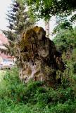 | Menhir de Chavannes
| Chavannes
(Cher) | Saint Amand Montrond |
| 34 Km | | CHPRUN-0 | | Château de Prunget
| Tendu
(Indre) | Châteauroux |
| 34,1 Km | | DLTHIB-3 | .jpg) | Dolmen des Thibauds
| Tendu
(Indre) | Châteauroux |
| 34,5 Km | | FVCHT1-0 | | Oppidum de Châteaumeillant
| Châteaumeillant
(Cher) | Châtre |
| 34,7 Km |  | ALCHA6 X | | Dolmen de Champ-des-Pierres-Folles
| Nohant en Graçay
(Cher) | Vierzon |
| 34,7 Km | | DLPENCX0 | | Dolmen des Penches
| Châteaumeillant
(Cher) | Châtre |
| 35,7 Km | | TMGABA 0 | | Tumulus des Gabats
| Tendu
(Indre) | Châteauroux |
| 36,2 Km | | VICHAT-0 | | Village Celte des Chateliers
| Moulins sur Céphons
(Indre) | Châteauroux |
|
|
| © 2004-2024 T4T35 - Version du 3 décembre 2020 22:31 - Email : T4T35 |
|

 Belgique
 Ecosse
 France
 Irlande
 Pays de Galles