| Distance | | ID Site | Photo | Description | Commune
(Département) | Ville proche |
|---|
|
| 0 Km |  | DLCABA-4 |  | Dolmen dit La Cabane de la Fée
| Beynat
(Corrèze) | Tulle |
| 1,8 Km |  | DLFONC 0 | | Dolmen de Fontourcy
| Beynat
(Corrèze) | Brive la Gaillarde |
| 4,1 Km |  | TPAVR0-- | | La Commanderie - A vérifier
| Albussac
(Corrèze) | Tulle |
| 4,3 Km |  | DLBO22+3 | | Dolmen de Rochesseux
Ermitage | Aubazines
(Corrèze) | Brive la Gaillarde |
| 4,5 Km |  | ABDOBA-4 | 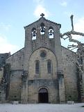 | Abbaye cistercienne d'Aubazine
| Aubazines
(Corrèze) | Brive la Gaillarde |
| 4,8 Km |  | LHPUYP+4 | | Cromlech de Puy de Pauliac
| Aubazines
(Corrèze) | Tulle |
| 6,8 Km | | DLTEIL 0 | | Dolmen de Teillol
| Albussac
(Corrèze) | Tulle |
| 7 Km |  | FOOPP0-0 | | Oppidum de la Roche de Vic
| Albussac
(Corrèze) | Tulle |
| 7,4 Km | ") | MNBOI1X0 | | Mégalithe du Bois de Marioule
| Cornil
(Corrèze) | Tulle |
| 9,7 Km |  | DLPUY0-2 | .jpg) | Dolmen du Puy de la Ramière
| Noailhac
(Corrèze) | Brive la Gaillarde |
| 10 Km | | PGBOSC-0 | | Pierre du Boscoudet
| Noailhac
(Corrèze) | Brive la Gaillarde |
| 10,9 Km |  | TMFRES 0 | | Tumulus de Fressinges
| Forgès
(Corrèze) | Tulle |
| 11,9 Km |  | FOCHTE - | | Oppidum dit le Châteaufort
| Ladignac sur Rondelles
(Corrèze) | Tulle |
| 13,6 Km | | DLBRA1 0 | | Dolmen de Combe Fosse
Brande | Jugeals Nazareth
(Corrèze) | Brive la Gaillarde |
| 16,6 Km | ") | FOSAI1X0 | | Fontaine Saint-Pierre
| Saint Paul
(Corrèze) | Tulle |
| 17,2 Km |  | CRGRA3 0 | | Gravures de Siorat
| Brive la Gaillarde
(Corrèze) | Brive la Gaillarde |
| 17,5 Km | | DLNOAI 0 | | Dolmen de la Route Vieille
| Noailles
(Corrèze) | Brive la Gaillarde |
| 17,7 Km |  | GTGIS6-0 | | Gisement préhistorique Bouffia Bonneval
| Chapelle aux Saints
(Corrèze) | Brive la Gaillarde |
| 17,8 Km | | FOPUYD-0 | | Oppidum du Puy-de-Tour
| Monceaux sur Dordogne
(Corrèze) | Tulle |
| 18 Km |  | MHGR03-2 |  | Menhir dit le Grave de Roland
Glaive de Roland | Argentat
(Corrèze) | Tulle |
| 18,9 Km |  | ROLONG 0 |  | Villa gallo-romaine de Longour
| Argentat
(Corrèze) | Tulle |
| 19,3 Km |  | MHVIE0 0 | | Menhir de Vieillemarette
| Gimel les Cascades
(Corrèze) | Tulle |
| 19,3 Km | | TPVRI2-- | | Le Temple (à vérifier)
| Monceaux sur Dordogne
(Corrèze) | Tulle |
| 19,7 Km | | GTMOU0-0 | | Grotte du moulin de Laguenay
Boissière | Lissac sur Couze
(Corrèze) | Brive la Gaillarde |
| 20,3 Km |  | TPMONS - | | Commanderie de Mons
| Varetz
(Corrèze) | Brive la Gaillarde |
| 20,9 Km | | TMPUYL 0 | | Tumulus du Puy de l'Aiguille
| Saint Martial de Gimel
(Corrèze) | Tulle |
| 21,1 Km | | EGNOH0-4 | 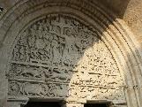 | Eglise Notre-Dame
Pénitents | Beaulieu sur Dordogne
(Corrèze) | Brive la Gaillarde |
| 21,1 Km |  | ROTINT-0 | | Ruines gallo-romaines de Tintignac
| Naves
(Corrèze) | Tulle |
| 21,3 Km |  | DLBOR3 3 | | Dolmen de la Borderie
Peyre-Levade | Altillac
(Corrèze) | Tulle |
| 21,5 Km | | FODUXE-0 | | Oppidum d'Uxellodunum
| Vayrac
(Lot) | Brive la Gaillarde |
| 22,2 Km | | DLMAZA 0 | | Dolmen de Mazajoux
| Chartrier Ferrière
(Corrèze) | Brive la Gaillarde |
|

 Accueil
 Belgique
 Ecosse
 France
 Irlande
 Pays de Galles